
World’s Top 20 Companies in Aerial Survey Services Market 2025: Industry Intelligence Report by Spherical Insights (2024–2035)
RELEASE DATE: Mar 2026 Author: Spherical InsightsRequest Free Sample Speak to Analyst
Description
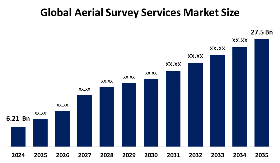
According to a research report published by Spherical Insights & Consulting, The Global Aerial Survey Services Market Size is projected to Grow from USD 6.21 Billion in 2024 to USD 27.5 Billion by 2035, at a CAGR of 14.49% during the forecast period 2025–2035. This industry delivers high-precision data for construction, agriculture, and environmental monitoring. It is propelled by rising urbanization, infrastructure development, and UAV technology improvements.
Introduction
Aerial survey services involve capturing processing and analyzing data such as images video LiDAR and multispectral information of the Earths surface using elevated platforms including unmanned aerial vehicles airplanes and helicopters to create maps models and actionable geospatial insights. North America Europe and Asia Pacific are leading regions in this market with significant growth expected in emerging economies. Countries such as the United States China Japan India and Germany dominate this market. Indias National Geospatial Mission backed by a 100 crore allocation aims to build foundational geospatial datasets modernize land records and strengthen urban planning boosting demand for aerial surveying drone mapping and advanced geospatial data services across infrastructure and governance sectors. Artificial intelligence and machine learning are transforming image processing by automating analysis improving accuracy and significantly reducing turnaround times. These technologies enable faster data interpretation enhanced pattern recognition and more efficient decision making across industries.
Unlock exclusive market insights—Download the Brochure now and dive deeper into the future of the Aerial Survey Services market.
Aerial Survey Services Market Size & Statistics
- The Market Size for Aerial Survey Services Was Estimated to be worth USD 6.21 Billion in 2024.
- The Market Size is Going to Expand at a CAGR of 14.49% between 2025 and 2035.
- The Global Aerial Survey Services Market Size is anticipated to reach USD 27.5 Billion by 2035.
- Asia Pacific is estimated to generate the highest demand during the forecast period in The Aerial Survey Services Market.
- North America is projected to grow the fastest during the forecast period in The Aerial Survey Services Market
Regional growth and demand
North America is expected to grow the fastest during the forecast period in the aerial survey services market. The rapid adoption of drone technology increasing demand for geospatial data and expanding infrastructure development in the United States and Canada are driving market growth. In 2023 the region witnessed significant investments in drone based mapping and surveying solutions to improve efficiency and data accuracy. The United States led the market due to strong technological innovation and the presence of major aerial survey service providers. The FAA has played a crucial role in accelerating commercial drone adoption in the US by establishing regulatory frameworks for survey mapping and inspection operations supporting the growth of aerial survey services in North America and globally.
Asia Pacific is anticipated to generate the highest demand during the forecast period in the aerial survey services market. The regions growth is driven by rapid infrastructure development increasing adoption of drone technology and rising demand for geospatial mapping in countries such as China and India. In April 2025 Japan based Terra Drone expanded its advanced drone technology ecosystem deploying solutions to enhance aerial survey efficiency and data capture strengthening its presence in the global aerial survey services market particularly across the Asia Pacific region.
Top 10 trends in the Aerial Survey Services Market
- Dominance of UAVs
- Advanced LiDAR Integration
- BVLOS (Beyond Visual Line of Sight) Operations
- AI and Machine Learning for Data Analysis
- 3D Mapping and Digital Twins
- Cloud-Based Data Management
- Smart City and Infrastructure Planning
- Precision Agriculture and Environmental Monitoring
- Integration with GIS
- Focus on Sustainability
- Dominance of UAVs (Drones):
Compared to conventional manned aircraft, drones offer greater flexibility, cheaper prices, and centimeter-level accuracy, making them the fastest-growing platform.
- Advanced LiDAR Integration:
More lightweight LiDAR sensors are being used on drones for landscape modeling and high-density 3D mapping.
- BVLOS (Beyond Visual Line of Sight) Operations:
Changes in regulations that permit longer flights are essential for linear infrastructure inspections (power lines, pipelines).
- AI and Machine Learning for Data Analysis:
Automated, real-time processing of large datasets for object identification, classification, and analysis.
- 3D Mapping and Digital Twins:
Producing high-fidelity 3D models for digital twin generation, construction progress tracking, and urban planning.
Empower your strategic planning:
Stay informed with the latest industry insights and market trends to identify new opportunities and drive growth in the temporary power market. To explore more in-depth trends, insights, and forecasts, please refer to our detailed report.
Unlock exclusive market insights—Download the Brochure now and dive deeper into the future of the Aerial Survey Services market.
Top 20 Companies Leading the Aerial Survey Services Market
- Terra Drone Corp
- Aerodyne Group
- Wingtra
- Delair
- PrecisionHawk
- Trimble Inc.
- Fugro N.V.
- Hexagon AB
- Topcon Corporation
- Nearmap
- EagleView Technology
- senseFly
- Parrot Drones SAS
- Aereo
- Asteria Aerospace
- Skylark Drones
- ideaForge
- IG Drones
- Aarav Unmanned Systems (AUS)
- Cyberhawk Innovations Limited.
- Terra Drone Corp
Headquarters: Tokyo, Japan
Terra Drone Corporation is a Japanese technology company founded in 2016 that specializes in drone-based surveying, mapping, inspection, and geospatial data solutions. The company provides advanced aerial survey services for industries such as construction, mining, oil and gas, and infrastructure development. Terra Drone operates globally with offices across Asia, Europe, and the Americas and reported strong growth as demand for drone-based data services increases.
- Aerodyne Group
Headquarters: Cyberjaya, Malaysia
Aerodyne Group is a Malaysian technology company founded in 2014 that specializes in drone-based inspection, aerial surveying, and data analytics services for industries such as energy, infrastructure, agriculture, and telecommunications. The company operates in numerous countries across Asia, the Middle East, Africa, and the Americas, providing advanced drone-powered enterprise solutions.
- Wingtra
Headquarters: Zurich, Switzerland
Wingtra AG is a Switzerland-based technology company founded in 2016 that specializes in the development of advanced vertical take-off and landing (VTOL) drones for aerial surveying and mapping applications. The company provides high-precision drone solutions used in industries such as construction, mining, agriculture, and environmental monitoring. Wingtra operates globally through a network of partners and customers across multiple regions.
- Delair
Headquarters: Toulouse, France
Delair is a French technology company founded in 2011 that specializes in the development of industrial drones and aerial data solutions for surveying, inspection, and mapping applications. The company provides advanced drone platforms and analytics software used across industries such as energy, mining, agriculture, and infrastructure. Delair operates globally with clients in numerous countries and focuses strongly on research and technological innovation.
- PrecisionHawk
Headquarters: Raleigh, North Carolina, United States
PrecisionHawk is an American technology company founded in 2010 that specializes in drone-based aerial surveying, remote sensing, and data analytics solutions. The company provides advanced aerial intelligence platforms used in industries such as agriculture, energy, telecommunications, insurance, and infrastructure. PrecisionHawk operates globally and focuses on delivering high-quality geospatial data to improve operational efficiency and decision-making.
Unlock exclusive market insights—Download the Brochure now and dive deeper into the future of the Aerial Survey Services market.
Company Profiles
- Terra Drone Corp
- Business Overview
- Company Snapshot
- Products Overview
- Company Market Share Analysis
- Company Coverage Portfolio
- Financial Analysis
- Recent Developments
- Merger and Acquisitions
- SWOT Analysis
- Aerodyne Group
- Wingtra
- Delair
- PrecisionHawk
- Trimble Inc.
- Fugro N.V.
- Hexagon AB
- Topcon Corporation
- Nearmap
- EagleView Technology
- senseFly
- Parrot Drones SAS
- Aereo
- Asteria Aerospace
- Skylark Drones
- ideaForge
- IG Drones
- Aarav Unmanned Systems (AUS)
- Cyberhawk Innovations Limited.
Our Top Reports:
https://www.sphericalinsights.com/reports/sepsis-treatment-market
https://www.sphericalinsights.com/reports/generative-ai-in-packaging-market
https://www.sphericalinsights.com/reports/ai-visual-inspection-system-market
https://www.sphericalinsights.com/reports/civilized-underground-bunker-market
Conclusion
The global aerial survey services market is expected to witness strong and sustained growth over the forecast period, driven by rapid technological advancements and the increasing demand for high-precision geospatial data across multiple industries. The widespread adoption of unmanned aerial vehicles, advanced LiDAR systems, and AI-powered data analytics is significantly improving the efficiency, accuracy, and scalability of aerial data collection and processing. Growing infrastructure development, smart city initiatives, and the expansion of precision agriculture and environmental monitoring applications are further accelerating market demand. Regionally, Asia-Pacific is emerging as the largest demand center due to rapid urbanization and infrastructure expansion, while North America continues to lead in technological innovation and regulatory support for commercial drone operations.
About the Spherical Insights & Consulting
Spherical Insights & Consulting is a market research and consulting firm which provides actionable market research study, quantitative forecasting and trends analysis provides forward-looking insight especially designed for decision makers and aids ROI.
Which is catering to different industry such as financial sectors, industrial sectors, government organizations, universities, non-profits and corporations. The company's mission is to work with businesses to achieve business objectives and maintain strategic improvements.
CONTACT US:
For More Information on Your Target Market, Please Contact Us Below:
Phone: +1 303 800 4326 (the U.S.)
Phone: +91 90289 24100 (APAC)
Email: inquiry@sphericalinsights.com, sales@sphericalinsights.com
Contact Us: https://www.sphericalinsights.com/contact-us
Need help to buy this report?