Global Satellite Imaging Market Size By Application (Geospatial Data Acquisition, Navigation & Mapping, Defense & Intelligence, Surveillance & Security, and Others), By End user (Government, Defense, Commercial, and Others), By Region, And Segment Forecasts, By Geographic Scope And Forecast to 2033
Industry: Aerospace & DefenseGlobal Satellite Imaging Market Insights Forecasts to 2033
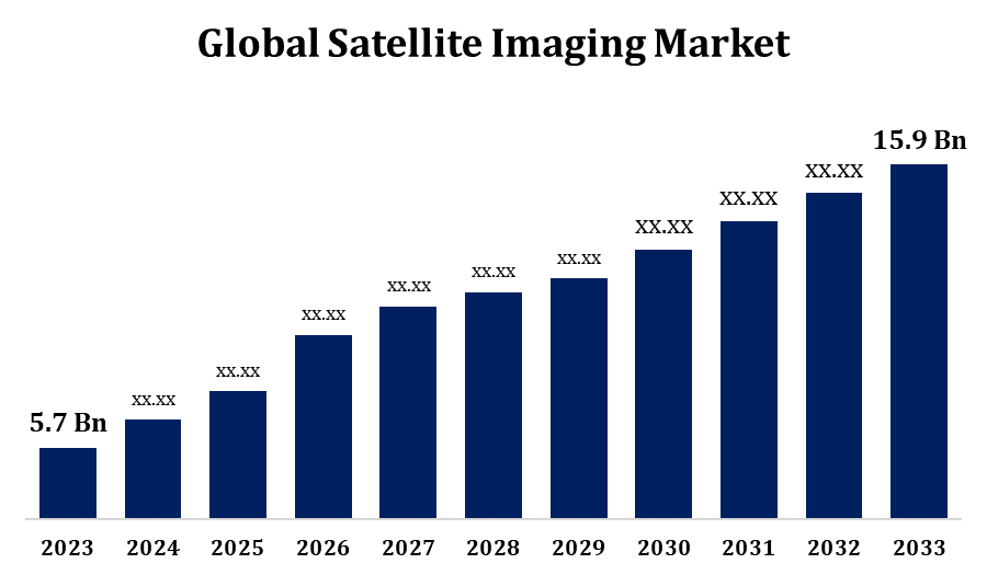
- The Global Satellite Imaging Market Size was valued at USD 5.7 Billion in 2023
- The Market Size is growing at a CAGR of 10.80% from 2023 to 2033
- The Worldwide Satellite Imaging Market is expected to reach USD 15.9 Billion by 2033
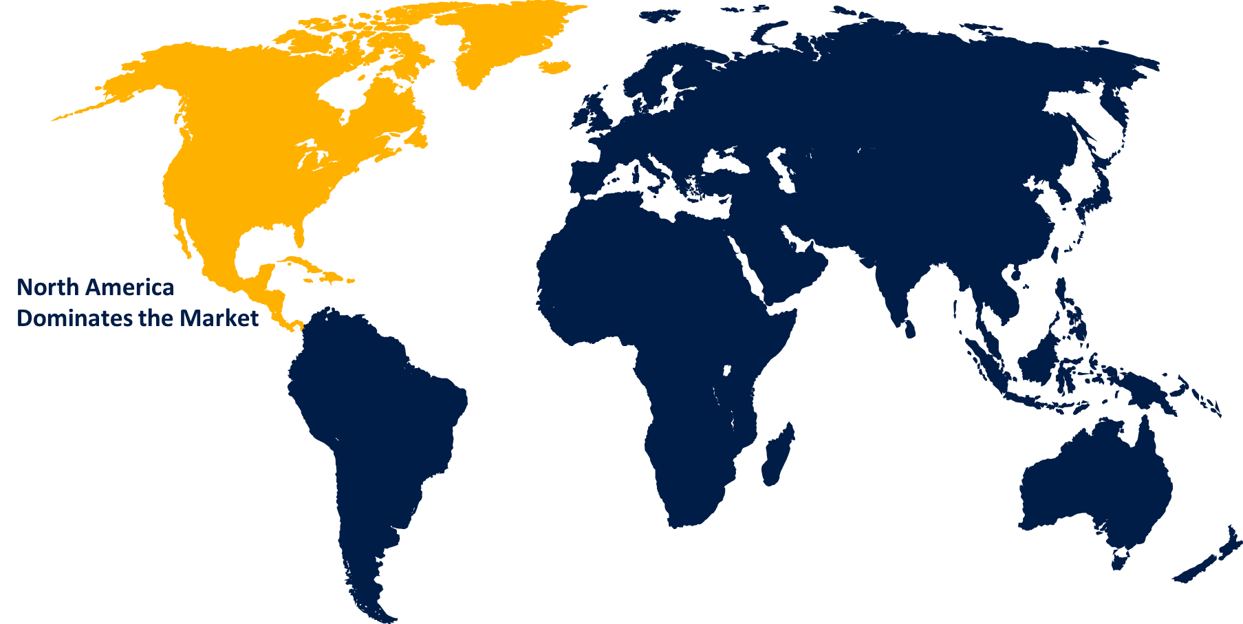
- Asia Pacific Market is expected to grow the fastest during the forecast period
Get more details on this report -
The Global Satellite Imaging Market Size is expected to reach USD 15.9 Billion by 2033, at a CAGR of 10.80% during the forecast period 2023 to 2033.
The commercial and government sectors have been placing an increasing amount of demand on satellite imagery. Governments employ satellite imagery for defence surveillance, environmental monitoring, and urban planning, among other purposes. Applications including infrastructure development, disaster response, and agricultural monitoring are among the uses of satellite images that businesses employ. Numerous sectors are discovering new uses for satellite imagery. For instance, crop monitoring, yield prediction, and precision farming in agriculture are all made possible by satellite images. Satellite photos help with infrastructure planning, land use analysis, and urban sprawl monitoring in urban planning. In the energy industry, environmental impact assessments, pipeline monitoring, and site selection are all done using satellite images.
Satellite Imaging Market Value Chain Analysis
Satellite manufacturing is the process of creating, building, and testing spacecraft that carry imaging payloads. Based on the needs of the end users and applications, satellite makers design spacecraft with a variety of specifications, such as image resolution, spectral bands, and orbital parameters. After construction, satellites must be deployed into orbit. Launch companies are in charge of putting satellites into their assigned orbits. Satellites go through a number of procedures to activate and commission their image systems after launch. Optical or synthetic aperture radar (SAR) instruments are examples of onboard imaging sensors that satellites use to take pictures of the Earth's surface. Scheduling satellite passes over particular places and modifying imaging settings are necessary for image capture. Users receive processed satellite imagery via a variety of media, including the internet. Applications and industries for satellite images are numerous and include forestry, agriculture, urban planning, defence, disaster management, transportation, and natural resource management.
Satellite Imaging Market Opportunity Analysis
There are a lot of prospects for market expansion due to developments in satellite imaging technology, including better spectral capabilities, data processing algorithms, and sensors with higher resolutions. Putting money into research and development (R&D) to create novel imaging methods and applications can provide businesses a competitive edge and meet changing consumer needs. Creating integrated solutions with real-time monitoring, machine learning, and spatial analytics combined with satellite imagery can provide value-added services to a variety of applications and sectors. Satellite imaging companies can investigate unexplored areas and sectors where satellite data can offer insightful analysis and practical solutions. Reaching underserved and isolated areas with satellite imaging coverage offers chances to fill gaps and advance sustainable development objectives.
Global Satellite Imaging Market Report Coverage
| Report Coverage | Details |
|---|---|
| Base Year: | 2023 |
| Market Size in 2023: | USD 5.7 Billion |
| Forecast Period: | 2023-2033 |
| Forecast Period CAGR 2023-2033 : | 10.80% |
| 2033 Value Projection: | USD 15.9 Billion |
| Historical Data for: | 2019-2022 |
| No. of Pages: | 200 |
| Tables, Charts & Figures: | 110 |
| Segments covered: | By Application, By End user, By Region, By Geographic Scope |
| Companies covered:: | BlackSky, European Space Imaging, Galileo Group, Inc., ImageSat, L3Harris Technologies, Inc., Maxar Technologies Inc., Planet Labs Inc., Airbus S.A.S., SpaceKnow Inc., Telespazio France, and Other Key Vendors. |
| Growth Drivers: | Introducing New Sensors and Data Sets by Market Players |
| Pitfalls & Challenges: | COVID-19 Empact,Challenges, Future, Growth, & Analysis |
Get more details on this report -
Market Dynamics
Satellite Imaging Market Dynamics
Introducing New Sensors and Data Sets by Market Players
Players in the market might launch satellites with more spectral bands and higher spatial resolution, allowing for more thorough and in-depth observation of the Earth's surface. The ability to combine data from various sources, including aerial surveys, ground sensors, and Internet of Things (IoT) devices, with satellite imaging is a potential capability that market players may develop. Demand for integrated solutions is fueled by providers' ability to give more thorough and useful insights by combining multi-source data sets for applications including infrastructure management, smart city planning, and natural resource monitoring. By utilising cutting-edge data analytics methods like artificial intelligence and machine learning, market participants can more precisely and effectively extract useful insights from satellite photos.
Restraints & Challenges
There are significant up-front and continuing expenses associated with the development, deployment, and maintenance of satellites for imaging applications. High costs for data processing, ground infrastructure, launch services, and satellite manufacture can be a financial obstacle for market participants, especially startups and small and medium-sized businesses (SMEs). There are many companies in the satellite imaging sector that compete fiercely to supply comparable goods and services. Reduced profit margins, commoditization of offerings, and price pressure are all consequences of intense competition. Additionally, the introduction of new companies and the diversity of the market may be diminished by market consolidation brought about by mergers, acquisitions, and partnerships. The value and usefulness of satellite imagery for end users can be increased by integrating it with other geospatial data sources, such as aerial surveys, ground observations, and Internet of Things (IoT) devices.
Regional Forecasts
North America Market Statistics
Get more details on this report -
North America is anticipated to dominate the Satellite Imaging Market from 2023 to 2033. North America's commercial sector is a significant user of satellite imagery for a range of purposes. Satellite imaging is used in a variety of industries, including agriculture, energy, mining, construction, insurance, and transportation, for tasks including asset management, market analysis, infrastructure planning, crop monitoring, and risk assessment. For the purposes of reconnaissance, surveillance, and situational awareness, satellite imaging is heavily utilised by the defence and intelligence communities in North America. High-resolution satellite imagery is used by government agencies, military branches, and defence contractors to monitor geopolitical trends, evaluate security concerns, and assist military operations. A thriving ecosystem of satellite imaging businesses, research centres, and innovation hubs dedicated to creating novel technology and applications may be found throughout North America.
Asia Pacific Market Statistics
Asia Pacific is witnessing the fastest market growth between 2023 to 2033. The satellite imaging market is expanding rapidly in the Asia-Pacific area due to the swift progress in satellite technology, augmented expenditure in space programmes, and expanding utilisation of satellite imagery for a wide range of purposes. The market is expected to grow across a number of industries, including natural resource management, infrastructure development, agriculture, urban planning, and catastrophe monitoring. Satellite imaging businesses have a lot of opportunity in the Asia-Pacific commercial market to provide goods and services that are specifically catered to the demands of regional consumers. Satellite imaging is used for land use planning, crop monitoring, infrastructure development, and site selection in a variety of industries, including telecommunications, construction, mining, forestry, and agriculture.
Segmentation Analysis
Insights by Application
The geospatial data acquisition segment accounted for the largest market share over the forecast period 2023 to 2033. The need for accurate and high-resolution satellite imaging with more spatial detail is expanding. Consequently, satellite operators are making investments in cutting-edge imaging sensors that can acquire high-definition imagery in order to satisfy the demands of many applications, including environmental monitoring, precision agriculture, urban planning, and infrastructure construction. Players in the market for satellite imaging are always coming up with new ideas and fighting to set themselves apart with their offers for geospatial data collecting. New satellite platforms, sensor technologies, data processing algorithms, and value-added services are being invested in due to competition in an effort to improve data quality, coverage, and usability for a variety of applications and end users.
Insights by End User
The commercial segment accounted for the largest market share over the forecast period 2023 to 2033. Due to cost reductions in launch services, data processing, and satellite production brought about by the commercialization of satellite imaging, satellite imagery is now more widely available and affordable for a wider range of consumers. Startups, small and medium-sized businesses (SMEs), and nonprofits can now enter the market and use satellite images for a variety of purposes thanks to declining costs. A growing number of businesses and uses, such as forestry, agriculture, infrastructure development, urban planning, defence, telecommunications, and disaster management, use satellite images. The commercial segment uses satellite images to provide actionable insights, value-added services, and customised solutions to meet the demands of these businesses.
Recent Market Developments
- In December 2022, the Alps' ice cover, persistent snow area, and snow status characteristics were continuously monitored by scientists from the European Space Agency (ESA). The Copernicus satellite collected this data. to possess greater knowledge and ability.
Competitive Landscape
Major players in the market
- BlackSky
- European Space Imaging
- Galileo Group, Inc.
- ImageSat
- L3Harris Technologies, Inc.
- Maxar Technologies Inc.
- Planet Labs Inc.
- Airbus S.A.S.
- SpaceKnow Inc.
- Telespazio France
Market Segmentation
This study forecasts revenue at global, regional, and country levels from 2023 to 2033.
Satellite Imaging Market, Application Analysis
- Geospatial Data Acquisition
- Navigation & Mapping
- Defense & Intelligence
- Surveillance & Security
- Others
Satellite Imaging Market, End User Analysis
- Government
- Defense
- Commercial
- Others
Satellite Imaging Market, Regional Analysis
- North America
- US
- Canada
- Mexico
- Europe
- Germany
- Uk
- France
- Italy
- Spain
- Russia
- Rest of Europe
- Asia Pacific
- China
- Japan
- India
- South Korea
- Australia
- Rest of Asia Pacific
- South America
- Brazil
- Argentina
- Rest of South America
- Middle East & Africa
- UAE
- Saudi Arabia
- Qatar
- South Africa
- Rest of Middle East & Africa
Frequently Asked Questions (FAQ)
-
1. What is the market size of the Satellite Imaging Market?The global Satellite Imaging Market is expected to grow from USD 5.7 billion in 2023 to USD 15.9 billion by 2033, at a CAGR of 10.80% during the forecast period 2023-2033.
-
2. Who are the key market players of the Satellite Imaging Market?Some of the key market players of the market are BlackSky, European Space Imaging, Galileo Group, Inc., ImageSat, L3Harris Technologies, Inc., Maxar Technologies Inc., Planet Labs Inc., Airbus S.A.S., SpaceKnow Inc., and Telespazio France.
-
3. Which segment holds the largest market share?The commercial segment holds the largest market share and is going to continue its dominance.
-
4. Which region is dominating the Satellite Imaging Market?North America is dominating the Satellite Imaging Market with the highest market share.
Need help to buy this report?