Top 25 Companies in Global Commercial Satellite Imaging Market: Global Share, Market Size, Revenue Report (2026–2035)
RELEASE DATE: Apr 2026 Author: Spherical InsightsRequest Free Sample Speak to Analyst
Introduction
The Commercial Satellite Imaging market refers to the industry focused on capturing and delivering Earth observation data using privately operated satellites for analysis and decision-making. Key raw materials include advanced sensors, imaging payloads, semiconductors, and satellite-grade materials. Market growth is driven by increasing demand for real-time geospatial intelligence, defense surveillance, and environmental monitoring. Applications span agriculture, urban planning, disaster management, mining, and infrastructure development. Governments worldwide are supporting the sector through space policies, funding programs, and public-private partnerships to enhance national security and digital mapping capabilities. Recent developments include the launch of high-resolution imaging satellites and the expansion of small satellite constellations by private firms. In March 2024, global space agencies and companies increased investments in Earth observation programs to strengthen climate monitoring and security operations. Technological advancements such as AI-powered image analytics, cloud-based geospatial platforms, and improved data processing capabilities are further accelerating market expansion and accessibility.
Navigate Future Markets with Confidence: Insights from Spherical Insights LLP
The insights presented in this blog are derived from comprehensive market research conducted by Spherical Insights LLP, a trusted advisory partner to leading global enterprises. Backed by in-depth data analysis, expert forecasting, and industry-specific intelligence, our reports empower decision-makers to identify strategic growth opportunities in fast-evolving sectors. Clients seeking detailed market segmentation, competitive landscapes, regional outlooks, and future investment trends will find immense value in the full report. By leveraging our research, businesses can make informed decisions, gain a competitive edge, and stay ahead in the transition toward sustainable and profitable solutions.
In March 2026, Rocket Lab launched radar imaging satellites for Synspective and the European Space Agency, supporting the expansion of commercial Earth observation constellations for urban monitoring and navigation systems.
In March 2026, China successfully tested an in-orbit satellite refueling system using a robotic arm, enabling longer satellite lifespans and improving the efficiency of imaging constellations.
Unlock exclusive market insights—Download the Brochure now and dive deeper into the future of the Commercial Satellite Imaging Market.
Market Segmentation
Global Commercial Satellite Imaging Market Size, Share, and COVID-19 Impact Analysis, By Type (Optical Imaging, Radar Imaging, Thermal Imaging), By Application (Defense and Intelligence, Agriculture and Forestry, Energy and Utilities, Urban Development and Infrastructure, Disaster Management), By End-User (Government, Commercial Enterprises), By Region (North America, Europe, Asia Pacific, Latin America, Middle East and Africa), Analysis and Forecast, 2026–2035.
Commercial Satellite Imaging Market Size & Statistics
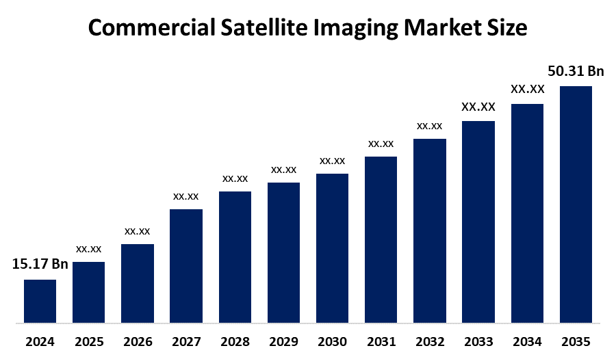
- The Market Size for Commercial Satellite Imaging Was Estimated to be worth USD 15.17 Billion in 2025.
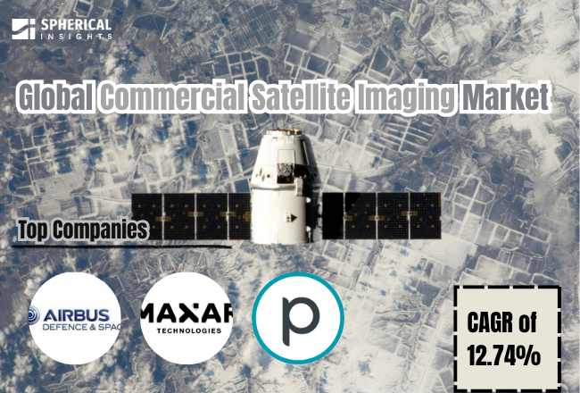
- The Market is Going to Expand at a CAGR of 12.74% between 2026 and 2035.
- The Global Commercial Satellite Imaging Market Size is anticipated to reach USD 50.31 Billion by 2035.
- Asia Pacific is expected to grow the fastest during the forecast period in the Commercial Satellite Imaging Market.
- North America is expected to generate the highest demand during the forecast period in the Commercial Satellite Imaging market.
Regional growth and demand
Europe is expected to grow the fastest during the forecast period in the Commercial Satellite Imaging market. The region’s rapid growth is driven by strong investments in Earth observation programs, increasing demand for environmental monitoring, and rising adoption of geospatial intelligence across agriculture, maritime surveillance, and urban planning. Countries such as Germany, France, and the United Kingdom are supporting satellite imaging through space agencies and public-private partnerships. Government initiatives like the Copernicus Programme and climate monitoring policies are accelerating adoption. Additionally, growing focus on sustainability, disaster management, and cross-border security is further boosting market expansion across the region.
In April 2026, the European Space Agency advanced its Earth observation capabilities by enabling user access to Sentinel-1D satellite data under the Copernicus programme, strengthening Europe’s real-time environmental monitoring and imaging infrastructure.
In February 2026, European Commission reports highlighted that Copernicus satellite assets are playing a critical role in aviation monitoring, climate tracking, and geospatial intelligence, reinforcing Europe’s leadership in commercial satellite imaging services.
Unlock exclusive market insights—Download the Brochure now and dive deeper into the future of the Commercial Satellite Imaging Market.
Asia Pacific is expected to generate the highest demand during the forecast period in the Commercial Satellite Imaging market. Demand is driven by increasing satellite launches, rising defense and border surveillance needs, and growing utilization of satellite imagery in infrastructure development and agriculture. Countries such as China and India are investing heavily in satellite constellations and geospatial data platforms. Expanding smart city projects, disaster response systems, and government-backed space initiatives, along with rapid technological advancements, are contributing to strong and sustained market demand across the region.
In March 2026, Chinese commercial satellites captured high-resolution images of military movements in the Asia-Pacific region, highlighting the increasing role of private satellite imaging companies in defense and surveillance applications.
Ready to lead the Commercial Satellite Imaging market
Discover the regional trends and growth factors shaping the industry. We’re here to assist with expert, personalized data.
Call +1 303 800 4326 or Send us a message for a personalized consultation.
Top 10 Trends in the Commercial Satellite Imaging Market
• Increasing demand for real-time geospatial intelligence
• Expansion of small satellite constellations
• Rising adoption in defense and surveillance applications
• Growing use in agriculture and environmental monitoring
• Integration of AI and machine learning in image analytics
• Advancements in high-resolution and hyperspectral imaging
• Increasing commercial participation in space industry
• Expansion of cloud-based geospatial data platforms
• Rising demand for disaster management and climate monitoring
• Strategic partnerships and satellite data commercialization
Unlock exclusive market insights—Download the Brochure now and dive deeper into the future of the Commercial Satellite Imaging Market.
Top 5 Trends
1. Increasing Demand for Real-Time Geospatial Intelligence
Governments and enterprises are increasingly relying on real-time satellite data for decision-making across defense, disaster response, and infrastructure planning. The need for timely and accurate Earth observation data is driving investments in high-frequency imaging satellites and analytics platforms, enabling users to monitor changes on the ground with greater precision and speed.
2. Expansion of Small Satellite Constellations
The deployment of low-cost small satellites and CubeSats is transforming the commercial satellite imaging landscape. Companies are launching large constellations to provide frequent revisit rates and global coverage, improving accessibility and reducing data latency for commercial and government users across industries.
3. Rising Adoption in Defense and Surveillance Applications
Satellite imaging is increasingly used for border monitoring, military intelligence, and maritime surveillance. Governments are investing in advanced imaging systems to enhance national security capabilities, leading to higher demand for high-resolution imagery and real-time monitoring solutions.
4. Integration of AI and Machine Learning in Image Analytics
Artificial intelligence and machine learning technologies are being integrated into satellite imaging workflows to automate image processing, object detection, and predictive analysis. These technologies improve efficiency, reduce manual interpretation, and enable faster insights from large volumes of geospatial data.
5. Advancements in High-Resolution and Hyperspectral Imaging
Technological innovations in imaging sensors are enabling higher resolution and hyperspectral capabilities, allowing detailed analysis of Earth’s surface. These advancements support applications such as mineral exploration, precision agriculture, and environmental monitoring, significantly enhancing the value of satellite-derived data.
Empower your strategic planning:
Stay informed with the latest industry insights and market trends to identify new opportunities and drive growth in the Commercial Satellite Imaging market. To explore more in-depth trends, insights, and forecasts, please refer to our detailed report.
Unlock exclusive market insights—Download the Brochure now and dive deeper into the future of the Commercial Satellite Imaging Market.
Top 25 Companies Leading the Commercial Satellite Imaging Market
- Maxar Technologies
- Planet Labs PBC
- Airbus Defence and Space
- BlackSky Technology Inc.
- Satellogic Inc.
- ICEYE
- Capella Space
- EarthDaily Analytics (formerly UrtheCast)
- SI Imaging Services (SIIS)
- GeoOptics Inc.
- Spire Global Inc.
- ImageSat International (ISI)
- Satrec Initiative Co., Ltd.
- e-GEOS (ASI/Telespazio)
- Telespazio S.p.A.
- Thales Alenia Space
- OHB SE
- Harris Geospatial Solutions (L3Harris Technologies)
- DigitalGlobe (Maxar Technologies)
- Orbital Insight
- Descartes Labs
- Planet IQ
- Synspective Inc.
- SkyWatch Space Applications Inc.
- Albedo Space
1. Maxar Technologies
Headquarters: Westminster, Colorado, United States
Maxar Technologies is a leading provider of high-resolution Earth observation data and geospatial intelligence solutions. The company operates advanced imaging satellites under its WorldView and GeoEye constellations, delivering highly detailed imagery for defense, intelligence, and commercial applications. Maxar’s capabilities are widely used in urban planning, disaster response, and environmental monitoring. The company focuses on innovation in high-resolution imaging, 3D mapping, and AI-powered geospatial analytics, supporting governments and enterprises globally. Its strong data analytics platform and long-standing contracts with defense agencies position it as a dominant player in the commercial satellite imaging market.
2. Planet Labs PBC
Headquarters: San Francisco, California, United States
Planet Labs operates one of the largest fleets of Earth observation satellites, capturing daily images of the entire planet. The company specializes in high-frequency, medium-resolution imaging using small satellite constellations known as Dove and SkySat. Planet’s data is widely used in agriculture, forestry, environmental monitoring, and defense intelligence. Its cloud-based platform enables real-time data access and analytics for customers worldwide. The company’s focus on scalable satellite constellations and AI-driven insights has significantly enhanced the accessibility and usability of satellite imagery across industries.
3. Airbus Defence and Space
Headquarters: Leiden, Netherlands / Paris, France
Airbus Defence and Space is a major player in satellite imaging and geospatial services, offering high-resolution optical and radar imagery through its Pléiades and TerraSAR-X satellite systems. The company provides data solutions for defense, security, climate monitoring, and urban development applications. Airbus integrates advanced analytics, AI, and cloud-based platforms to deliver actionable intelligence. With strong backing from European space programs, the company plays a key role in global Earth observation initiatives and commercial satellite imaging services.
4. BlackSky Technology Inc.
Headquarters: Herndon, Virginia, United States
BlackSky Technology specializes in real-time geospatial intelligence and monitoring services using a constellation of small satellites. The company provides high-revisit imagery combined with AI-driven analytics for defense, supply chain monitoring, and economic intelligence. Its platform delivers rapid insights by integrating satellite imagery with other data sources. BlackSky’s focus on time-sensitive intelligence and real-time monitoring makes it a key provider for government and commercial customers seeking actionable geospatial data.
5. Satellogic Inc.
Headquarters: Buenos Aires, Argentina
Satellogic is a vertically integrated Earth observation company that designs, manufactures, and operates its own satellite constellation. The company focuses on providing high-resolution imagery at low cost, making satellite data more accessible for commercial applications. Satellogic supports industries such as agriculture, energy, mining, and environmental monitoring. Its scalable satellite architecture and cost-efficient deployment model position it as an emerging competitor in the global satellite imaging market.
Unlock exclusive market insights—Download the Brochure now and dive deeper into the future of the Commercial Satellite Imaging Market.
Are you ready to discover more about the Commercial Satellite Imaging market?
The report provides an in-depth analysis of the leading companies operating in the global Commercial Satellite Imaging market. It includes a comparative assessment based on their product portfolios, business overviews, geographical footprint, strategic initiatives, market segment share, and SWOT analysis. Each company is profiled using a standardized format that includes:
Company Profiles
- Maxar Technologies
- Business Overview
- Company Snapshot
- Products Overview
- Company Market Share Analysis
- Company Coverage Portfolio
- Financial Analysis
- Recent Developments
- Merger and Acquisitions
- SWOT Analysis
2. Planet Labs PBC
3. Airbus Defence and Space
4. BlackSky Technology Inc.
5. Satellogic Inc.
6. ICEYE
7.Capella Space
8. EarthDaily Analytics (formerly UrtheCast)
9.SI Imaging Services (SIIS)
10. Others.
Conclusion
The Commercial Satellite Imaging market is poised for strong growth over the forecast period, driven by increasing demand for real-time geospatial intelligence, rising defense and surveillance needs, and expanding applications across agriculture, urban planning, and disaster management. Continuous advancements in satellite technologies, including high-resolution sensors, small satellite constellations, and AI-powered analytics, are significantly enhancing data accuracy and accessibility. Government initiatives, growing private sector participation, and strategic collaborations are further accelerating market expansion. Additionally, the integration of cloud-based platforms and automation in image processing is transforming how satellite data is utilized across industries. As global reliance on data-driven decision-making increases, the commercial satellite imaging market is expected to witness sustained innovation, broader adoption, and significant investment, positioning it as a critical component of the modern digital and space economy.
Other Industry Reports :
Top ulat20 Companies in Regory Affairs Outsourcing Market
Top 20 Companies in Keyboard Protector Keyboard Skin Market
High Voltage Connectors for Automobiles Market
Top 20 Companies in Fuel Antistat Market
Top 20 Companies in Beekeeping Equipment Market
About the Spherical Insights & Consulting
Spherical Insights & Consulting is a market research and consulting firm which provides actionable market research study, quantitative forecasting and trends analysis provides forward-looking insight especially designed for decision makers and aids ROI. Which is catering to different industry such as financial sectors, industrial sectors, government organizations, universities, non-profits and corporations. The company's mission is to work with businesses to achieve business objectives and maintain strategic improvements.
CONTACT US:
For More Information on Your Target Market, Please Contact Us Below:
Phone: +1 303 800 4326 (the U.S.)
Phone: +91 90289 24100 (APAC)
Email: inquiry@sphericalinsights.com, sales@sphericalinsights.com
Contact Us: https://www.sphericalinsights.com/contact-us
Need help to buy this report?