United Kingdom LiDAR Market Size, Share, and COVID-19 Impact Analysis, By Type (Airborne, Terrestrial, and Mobile & UAV), By Application (Corridor Mapping, Engineering, Environment, Exploration, ADAS, and Others), and UK LiDAR Market Insights, Industry Trend, Forecasts to 2035
Industry: Semiconductors & ElectronicsUnited Kingdom LiDAR Market Size Forecasts to 2035
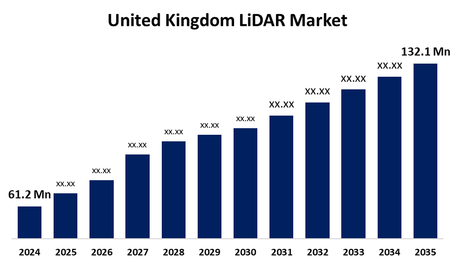
- The United Kingdom LiDAR Market Size Was Estimated at USD 61.2 Million in 2024
- The UK LiDAR Market Size is Expected to Grow at a CAGR of around 7.25% from 2025 to 2035
- The UK LiDAR Market Size is Expected to Reach USD 132.1 Million by 2035
Get more details on this report -
According to a Research Report Published by Spherical Insights & Consulting, the UK LiDAR Market Size is anticipated to reach USD 132.1 million by 2035, growing at a CAGR of 7.25% from 2025 to 2035. Growing need for high-precision mapping in forestry, urban planning, and construction, robust government financing through the UK Space Agency and Geospatial Strategy, and accelerated urbanisation driving infrastructure and transport project needs are all contributing factors to the UK LiDAR market's expansion.
Market Overview
The UK LiDAR Market Size refers to a remote sensing technology that uses laser pulses to measure distances and generate precise 3D maps. By calculating the time-of-flight of laser light, it creates detailed point clouds, enabling accurate surface and object detection across various applications. Technology and demand for quality data collection are revolutionizing the UK LiDAR market. The widespread use of LiDAR technology in agriculture, forestry, and town management is a primary market driver. LiDAR permits accurate mapping and analysis that further sustainability planning and environmental monitoring efforts. LiDAR applications have a lot of potential because of the UK's goal to reach net-zero emissions by 2050, which is driving for improved data collection techniques, especially in land use management. Recent patterns show that the UK government's emphasis on enhancing urban development and transport networks has led to a boom in the application of LiDAR technology in infrastructure projects. This trend is complemented by the rise of autonomous vehicles, which rely significantly on LiDAR for safety and navigation. Furthermore, LiDAR and GIS (Geographic Information Systems) integration is gaining traction, allowing for a more thorough data analysis that supports several government and corporate projects. The surveying and mapping of isolated or dangerous areas has shown this method to be very beneficial. As the UK continues to invest in digital infrastructure and smart cities, the need for creative and accurate LiDAR solutions will only grow, highlighting the technology's pivotal position in shaping the future of urban growth and environmental stewardship.
Report Coverage
This research report categorizes the market for the UK LiDAR market based on various segments and regions and forecasts revenue growth and analyses trends in each submarket. The report analyses the key growth drivers, opportunities, and challenges influencing the United Kingdom LiDAR market. Recent market developments and competitive strategies such as expansion, product launch, and development, partnership, merger, and acquisition have been included to draw the competitive landscape in the market. The report strategically identifies and profiles the key market players and analyses their core competencies in each sub-segment of the United Kingdom LiDAR market.
United Kingdom LiDAR Market Report Coverage
| Report Coverage | Details |
|---|---|
| Base Year: | 2024 |
| Market Size in 2024: | USD 61.2 Million |
| Forecast Period: | 2025-2035 |
| Forecast Period CAGR 2025-2035 : | 7.25% |
| 2035 Value Projection: | USD 132.1 Million |
| Historical Data for: | 2020-2023 |
| No. of Pages: | 123 |
| Tables, Charts & Figures: | 122 |
| Segments covered: | By Type, By Application and COVID-19 Impact Analysis |
| Companies covered:: | Velodyne LiDAR, Quantum Spatial, Unifly, Geoslam, Trimble, Leica Geosystems, Optech, Sensys Networks, LandTrac, Riegl Laser Measurement Systems, Topcon Positioning Systems, Hexagon AB, 3D Laser Mapping, Teledyne Technologies, and Other key vendors |
| Pitfalls & Challenges: | COVID-19 Empact, Challenge, Future, Growth, & Analysis |
Get more details on this report -
Driving Factors
The UK LiDAR market is experiencing massive growth due to high demand for precision mapping in industries like construction, forestry, and environmental monitoring. Government-backed initiatives like the Geospatial Strategy and the UK Space Agency's "International Partnership Programme" are also increasing the availability by putting funding behind consumers and projects that use LiDAR. In urban planning and infrastructure development, increased urbanization is creating additional demand for LiDAR data. Organizations, like the Ordnance Survey or Transport for London, are implementing LiDAR data into their operations to make better decisions using data.
Restraining Factors
The expensive price of LiDAR systems includes data processing, software, and hardware. Adoption may also be hampered by a lack of technical know-how and the difficulty of interpreting data, particularly in smaller businesses and industries with weak digital infrastructure or limited funding. These factors hamper the LiDAR market during the forecast period.
Market Segmentation
The United Kingdom LiDAR market share is classified into type and application.
- The airborne segment held the largest market share in 2024 and is expected to grow at a significant CAGR during the forecast period.
The United Kingdom LiDAR market is segmented by type into airborne, terrestrial, and mobile & UAV. Among these, the airborne segment held the largest market share in 2024 and is expected to grow at a significant CAGR during the forecast period. Increased use in large-scale surveying and mapping. Airborne LiDAR units are favored for mapping infrastructure and topography because they can cover large areas quickly and accurately. The technology is often employed in natural resource management and monitoring environmental changes due to its high accuracy in acquiring elevation data. Aerial LiDAR is an important source of spatial data for government programs related to disaster relief and infrastructure development.
- The corridor mapping segment held the highest revenue market share in 2024 and is expected to grow at a significant CAGR during the forecast period.
The United Kingdom LiDAR market is segmented by application into corridor mapping, engineering, environment, exploration, ADAS, and others. Among these, the corridor mapping segment held the highest revenue market share in 2024 and is expected to grow at a significant CAGR during the forecast period. Its importance is for projects with power lines, railroads, and highways. It provides incredibly detailed and accurate 3D maps that are vital to developing and maintaining linear infrastructure. LiDAR is the preferred method for corridor mapping because of its accuracy and ability to capture those areas of land quickly and with minimal human involvement. More and more, both governments and private companies are using LiDAR for utility corridor monitoring and inspection.
Competitive Analysis:
The report offers the appropriate analysis of the key organizations/companies involved within the United Kingdom LiDAR market and a comparative evaluation primarily based on their product offering, business overviews, geographic presence, enterprise strategies, segment market share, and SWOT analysis. The report also provides an elaborate analysis focusing on the current news and developments of the companies, which includes product development, innovations, joint ventures, partnerships, mergers & acquisitions, strategic alliances, and others. This allows for the evaluation of the overall competition within the market.
List of Key Companies
- Velodyne LiDAR
- Quantum Spatial
- Unifly
- Geoslam
- Trimble
- Leica Geosystems
- Optech
- Sensys Networks
- LandTrac
- Riegl Laser Measurement Systems
- Topcon Positioning Systems
- Hexagon AB
- 3D Laser Mapping
- Teledyne Technologies
- Others
Key Target Audience
- Investors
- Market players
- End-users
- Government Authorities
- Consulting and Research Firm
- Venture capitalists
- Value-Added Resellers (VARs)
Market Segment
This study forecasts revenue at United Kingdom, regional, and country levels from 2020 to 2035. Spherical Insights has segmented the United Kingdom LiDAR market based on the below-mentioned segments:
United Kingdom LiDAR Market, By Type
- Airborne
- Terrestrial
- Mobile & UAV
United Kingdom LiDAR Market, By Application
- Corridor Mapping
- Engineering
- Environment
- Exploration
- ADAS
- Others
Need help to buy this report?